Maps, Directions & Parking
Albion is just about the perfect place to be.
We’re about 90 miles west of Detroit and 175 miles east of Chicago. So we’re just a quick bus ride (we have a Greyhound station), train trip (Amtrak stop, too), plane flight (airports in Kalamazoo, Lansing, and Detroit) or car trip (we’re right off Interstate 94) from just about anywhere.
Where You’ll Find Us
Driving Directions
From eastbound I-94, take Exit 121 (Eaton Avenue/28 Mile Road) and turn right (south). Follow southbound Business I-94 to Michigan Avenue (M-99 East). Turn left (east) onto M-99. The campus will be on your right, between Huron and Mingo streets.
From westbound I-94, take Exit 124 (M-99) and turn right (south/west). Follow M-99 about three miles into town. The campus will be on your left, between Mingo and Huron streets.
From northbound M-99, follow the road as it becomes Superior Street in downtown Albion. Turn right (east) onto Erie Street. The main part of campus will be on your left, between Huron and Mingo streets.
By Air and Rail
Albion is approximately 80 miles from Detroit Metropolitan International Airport (DTW), 60 miles from Lansing Capital City Airport (LAN), and 45 miles from Kalamazoo-Battle Creek International Airport (AZO).
Amtrak provides national rail passenger service with daily stops in Albion, as well as Jackson and Battle Creek. Greyhound provides intercity bus transportation.
Finding Your Way Around Campus
Virtual Tour
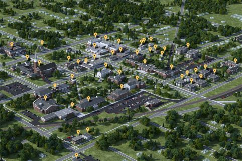
See Albion from a new angle! Explore our campus wherever you are with our interactive map.
Start ExploringCampus Map
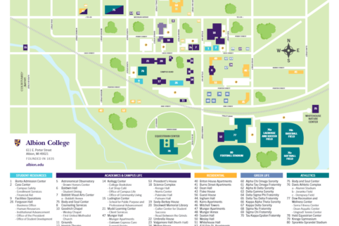
Download our campus map to plan out your next visit!
Download the Albion College Campus MapParking
Visitor parking is available in the lots next to the Bonta Admission Center and the Kellogg Center. Please note that the City of Albion does not allow street parking between 2 a.m. and 6 a.m.